Public Transport Navigation SMART-WAY

Concept

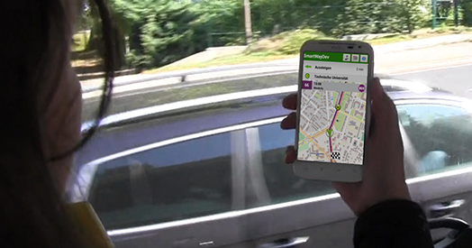
Being able to find one’s way within the transport network of big cities, to individually choose one’s means of transport and to be guided to one’s destination reliably and independent from interchanges and interruptions- that is the concept behind the public transport navigation system that was developed within the EU-funded project SMART-WAY.

Based on conventional connection information systems that are enhanced by real-time data, the SMART-WAY solution offers customers real navigation between one station and another. The users are able to move freely without any previous knowledge of either line network or schedules and because their location is constantly monitored, they will be reliably guided to their destination with the help of different means of transportation.

What exactly does the term real navigation mean? After all, mobile public transport information services in the shape of smartphone apps have existed for several years in many regions. In contrast to the existing services, the public transport navigation solution takes into account real-time data about the operating conditions of the transport network and will react to the actions of the users - for example, by calculating a new route to the destination if they deviate from the planned route.

The procedure is similar to that of a conventional navigation system for cars. In public transport navigation, however, additional factors must be considered, such as the schedules and their different cycle times, local peculiarities and current status information. Therefore, an individual, decentralized approach, which allows the integration of diverse schedule information systems, was chosen for SMART-WAY. Apart from lowering of access barriers, this approach creates more freedom for the passengers in the use of public transport. As a result, customers will choose the public transport mode more frequently and in greater numbers.

The public transport navigation solution is used in several follow-up projects: