Operative Regional Integrated and Optimized Corridor Control in Nuremberg

Outset

The Fraunhofer IVI determines traffic parameters online from video images using an especially developed method

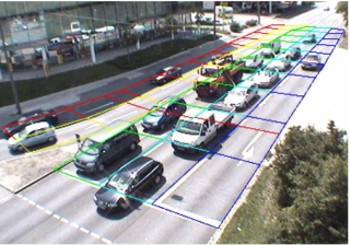
In the Operative Regional Integrated and Optimized Corridor Control in Nuremberg (ORINOKO) project, which was funded by the German Federation within the scope of the »Traffic Management 2010« research program, the Fraunhofer IVI developed practicle and financeable solution approaches for the comprehensive, city-wide identification of traffic states and for the improvement of the traffic light control system. In order to reach this aim, methods of data fusion and prognosis, as well as novel macroscopic, grid-adaptive control processes were analyzed and implemented as examples. Special focus was put on the solution approaches' transferability to other cities. On the basis of video detection and taxi-based floating car data (FCD), two traffic recording systems were developed and optimized that proved to be more cost-efficient than induction loops and that can be operated comprehensively throughout the entire city area.

The new data foundation can be used for quality control in road traffic, traffic information services and a more dynamic choice of signaling program.

The »Dynamic Traffic Management System Exhibition Center/Stadium/ARENA (VLS)«, a system installed in southern Nuremberg and equipped with an extensive number of sensors and actuators, was used as a research platform for the project. Using this system, it was possible to test the project results and products with regard to their efficacy in commuter traffic and event-related traffic. Travel time data from Nuremberg's taxi fleet comprising up to 500 vehicles and traffic data of the public transport network provided by the VAG data center were also used.

Project Outline

The Nuremberg Dynamic Traffic Management System (VLS) is well-suited as a test environment for Sensors and actuators used in the ORINOKO project

The main tasks that the Fraunhofer IVI carried out within the ORINOKO project were analyzing and optimizing the quality of the automated video detection system, investigating options for traffic data fusion and prognosis, developing a method for determining the location of detectors and implementing a tool that determines the interrelations between traffic jams and delays of buses and trams.  

The Fraunhofer IVI has many years of experience in developing image-based detection methods for road traffic. Within the ORINOKO project, the institute's researchers optimized a modular approach in which objects are identified using an image section that has been orthogonalized and normalized in terms of perspective. With this approach, it is possible to determine spatial utilization rates, the length of traffic jams, speeds and traffic densities as well as vehicle types (e. g., cars, trucks). With state-of-the-art computer technology, six to eight detection zones of up to 50 meters length each can be evaluated.

During the final stage of the project, the reliability of the approach was tested under different conditions (weather, geometry of view, and others). Both manual counts and automatically gathered comparison data was used in the process. Creating three-dimensional animations with the help of the VISSIM® microsimulation system by PTV AG has proven to be a very helpful method for the systematic evaluation of geometrical effects (view angles, distances, overlapping) on detection quality. On the basis of these animations, a standard method for the evaluation and certification of video detectors was designed within the project.

Aims

The fusion of traffic data from different sources (e. g. video, FCD, induction loops) is one of the current challenges in traffic management today. Especially the problem of connecting FCD information, which often contains spatial and temporal gaps and always refers to a certain route, with data gathered by stationary detectors is extensively investigated. Successfully fusing the two data types is a prerequisite for generating comprehensive and reliable traffic state images and short-term prognoses for traffic management tasks at any given time for any given road section.

To facilitate the aforementioned data fusion, the Fraunhofer IVI developed a method for the short-term prognosis of traffic flows on roads based on a similarity comparison of the space-time-patterns of different traffic parameters.

In this context, it is also interesting to know how many additional cross-section detectors will be necessary within a road network, provided a defined coverage level of FCD-generated measuring data can be relied upon. Here, the Fraunhofer IVI tested different approaches of multivariate data analysis and connected them in an innovative way.  

Furthermore, existing information about the schedule situation was systematically connected with the corresponding traffic state, statistically evaluated and contextually visualized using a so-called RBL info tool. The Fraunhofer IVI developed the necessary methods and implemented them subsequently. Requirements of function and ergonomics were designed in close collaboration with the future users.

Funding and Partners

The ORINOKO project was funded bei the German Federal Ministry of Education and Research (BMBF) within the scope of the »Verkehrsmanagement 2010 (Traffic Management 2010)« research initiative. The BMBF-appointed project developer was TÜV Management Systems GmbH.

Consortium partners:

  • City of Nuremberg (procekt coordinator)
  • Verkehrsplanungsamt (Office of Traffic Planning)
  • DLR German Aerospace Center
  • M.N.O. Stühler
  • Siemens AG
  • SSP Consult
  • Taxi-Zentrale Nürnberg (Nuremberg taxi control center)
  • VAG Verkehrsaktiengesellschaft Nürnberg
  • CNA Nürnberg